
WINTER ON THE MOUNTAIN
Find your kind of snow day.
First chair. A quiet Nordic loop. Your first turns. Build your day around the right terrain, a real map and the people who know the mountain.
Source review: · Our editorial approach
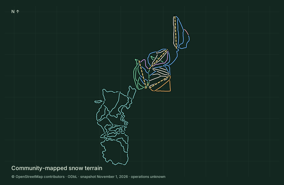
See the runs.
Meet the mountain.
Explore 35 mapped ski segments, 6 lift ways and 64 Nordic segments. These are community geometry counts, separate from the operator’s named-trail totals.
Explore the snow map in 3DMt. Shasta Ski Park
Lift-served skiing and snowboarding on the south side of Mount Shasta. Explore mapped runs and chairlifts, then use the operator’s current map, signs and report to choose your day.
Mt. Shasta Nordic Center
A separate community Nordic center for classic and skate skiing, with snowshoeing, lessons and rental equipment. Choose the operator’s groomed network and current report for the kind of day you want.
Three places. Different plans.
Mt. Shasta Ski Park
Resort chairlifts, ski and snowboard terrain, lessons and tubing. Use its ticket products, current operating report and on-mountain signs.
Ski Park guide ↗Mt. Shasta Nordic Center
A separate Nordic trail network and pass system. Check its map and grooming report for classic, skate and snowshoe outings.
Nordic guide ↗Old Ski Bowl & upper mountain
The former ski area is a backcountry mountain destination. This is not today’s lift-served Ski Park; do not expect resort services, patrol coverage or an open winter road.
Old Ski Bowl hazards ↗Start with the right preparation
Day tickets ↗
Choose your date and read age categories, availability, RFID requirements and change terms directly with the resort.
Season & multi-day passes ↗
Compare the current season pass, multi-day products, eligibility and partner restrictions. Prices and terms can change.
Ski & snowboard lessons ↗
Find private, group and school programs. Ask which lesson fits your experience; confirm age eligibility and whether lift access or equipment is included.
Adaptive programs ↗
Contact the Ski & Ride School about available adaptive equipment, instructor support, suitability and advance arrangements.
Reserve equipment ↗
Check ski or snowboard packages, helmet options, fitting needs and collection arrangements. A rental reservation is separate from permission to ride.
Tubing & family snow time ↗
Confirm the tubing hill is operating before travelling. The operator lists a minimum age of five and prohibits double riding; check all current rules and session details.
Keep the return part of the plan.
No uphill access; no closed-slope access
The operator’s winter policy prohibits uphill traffic and use of its slopes while closed. Groomers, equipment, cables and maintenance can create severe hazards. A map line does not grant access; contact the operator about any separately arranged activity.
A run on the map does not establish an open run
Stay within permitted, open terrain and obey patrol, ropes, signs and closures. This atlas does not verify operational or patrol boundaries. Freeride tags, map connections and satellite imagery do not establish an approved exit, traverse or return.
Winter operations, uphill policy and patrol contacts ↗ · Official trail map and lift statistics ↗
Control, space and lift skills
Choose terrain for your ability and the actual snow. Leave room for people downhill, look before merging, stop where visible and ask lift staff for help. Trees, deep snow, ice, terrain features and collisions can cause serious injury.
Outside resort operations is a different undertaking
Resort equipment or a lift ticket does not prepare you for avalanche terrain, navigation, self-rescue or ski mountaineering. Seek qualified instruction and a professional guide for backcountry objectives. Read the complete avalanche forecast; no rating is not a clearance.
Finish the day in the Shasta region
Sources, dates and map limits
Editorial review November 1, 2026. Geometry snapshot November 1, 2026 at 04:24 UTC. The map is incomplete and contains no verified operating, patrol or legal-access boundary. It does not route between runs or lifts, establish lift direction or current grooming, or authorize backcountry exits. Snow layers are separate from the hiking planner.
- Mt. Shasta Ski Park · Official trail map and lift statistics
- Mt. Shasta Ski Park · Lift tickets and purchase terms
- Mt. Shasta Ski Park · Season passes and pass options
- Mt. Shasta Ski Park · Ski & Ride School
- Mt. Shasta Ski Park · Adaptive lessons
- Mt. Shasta Ski Park · Equipment rentals
- Mt. Shasta Ski Park · Tubing information
- Mt. Shasta Ski Park · Snow, trail report and webcams
- Mt. Shasta Ski Park · Hours and operating updates
- Mt. Shasta Ski Park · Roads and parking
- Mt. Shasta Ski Park · Winter operations, uphill policy and patrol contacts
- Mt. Shasta Ski Park · Backcountry cabin information
- Mt. Shasta Nordic · Nordic Center information
- Mt. Shasta Nordic · Official Nordic trail map
- Mt. Shasta Nordic · Day passes and rentals
- Mt. Shasta Nordic · Nordic season passes
- Mt. Shasta Nordic · Nordic lessons
- Mt. Shasta Nordic · Grooming and conditions report
- Mount Shasta Avalanche Center · Avalanche forecast and climbing advisories
- Caltrans · State highway conditions and chain controls
Beyond the resorts: north and east forest snow routes
Explore Forest Service SNOW inventory around Whaleback, Deer Mountain and the east side of Shasta. These source lines are separate from summer hiking trails and resort operations. Current use permissions, grooming, patrol and access are unverified.